Petroleum Exploration Licence 105
PEL 105 — Owambo Basin, Namibia
PEL 105 is Exito Energy Resources’ core exploration asset in Namibia, covering Blocks 1718 and 1818 in the onshore Owambo Basin.
PEL 105 — Licence Outline (Schematic)
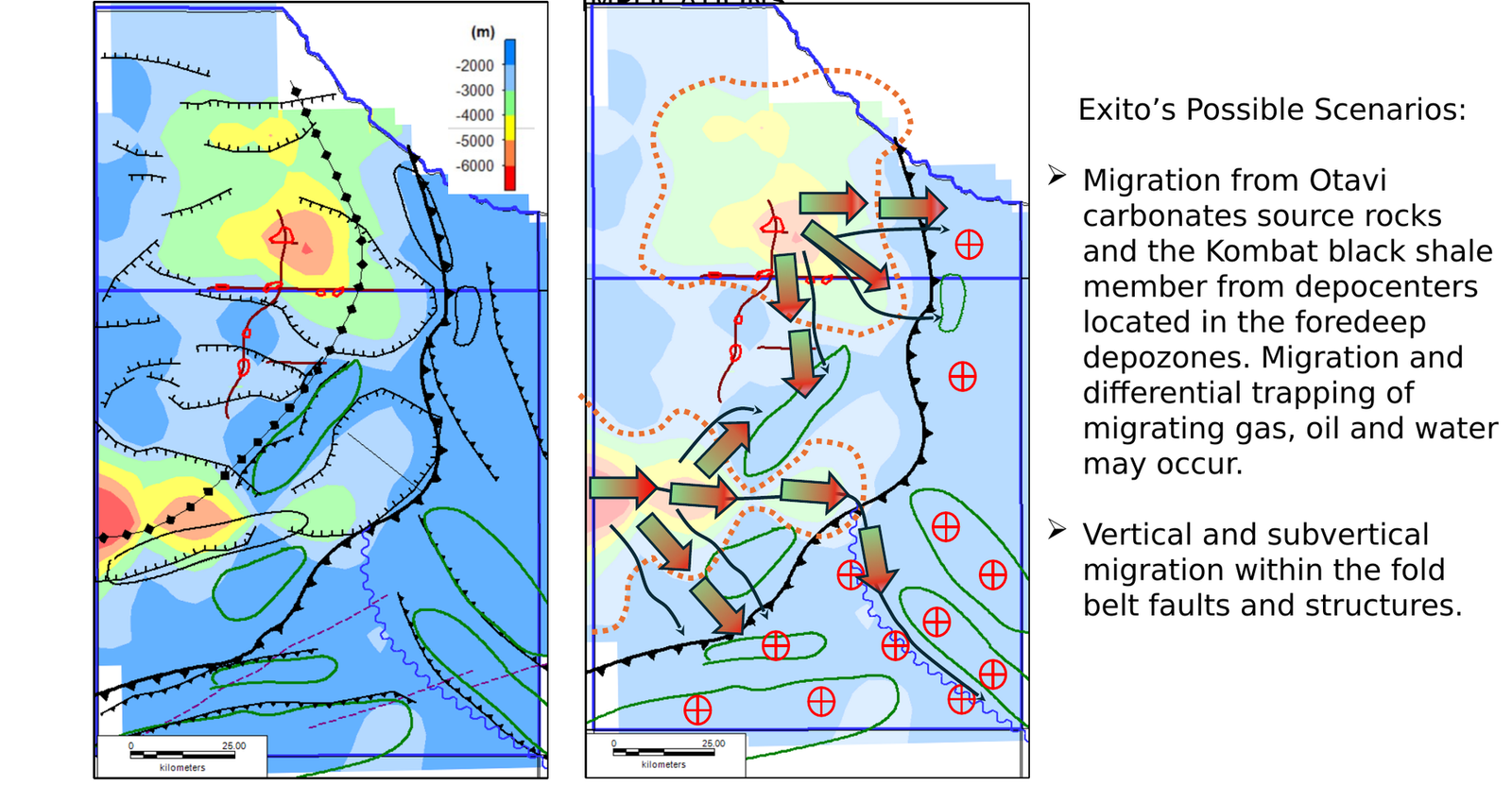
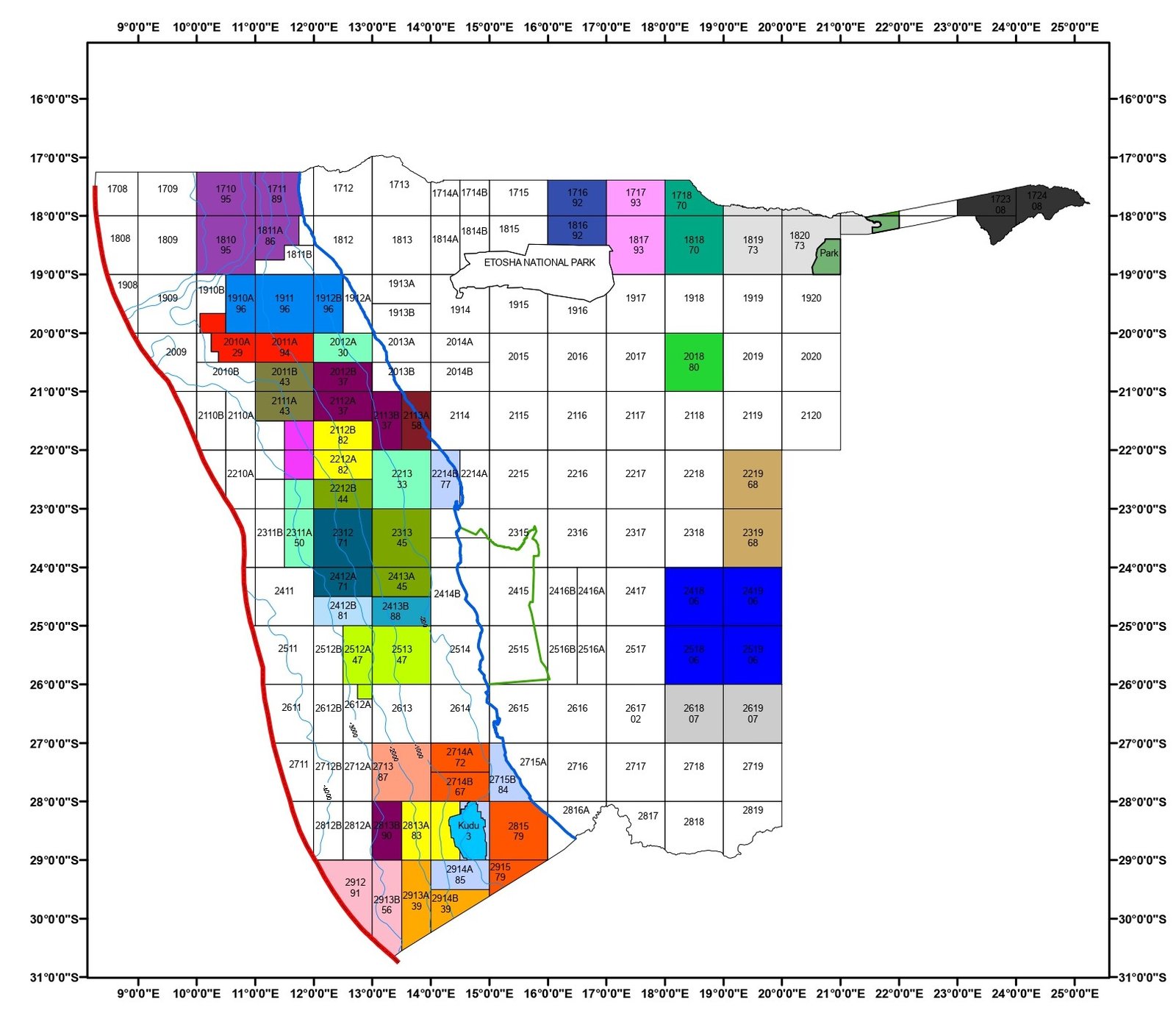
Schematic licence outline of PEL 105, Blocks 1718 and 1818, onshore Owambo Basin.
Asset Overview
PEL 105 Licence Location
PEL 105 licence location, covering Blocks 1718 and 1818 in the onshore Owambo Basin of Namibia.
≈ 17,035 km²Licence area
2 blocks1718 & 1818
| Licence | Petroleum Exploration Licence 105 (PEL 105) |
|---|---|
| Location | Onshore Owambo Basin, northern Namibia |
| Blocks | 1718 and 1818 |
| Area | Approximately 17,035 km² |
| Issued | 3 October 2022 |
| Current phase | Initial Exploration Period |
| Collaboration partner | Monitor (MEL Oil & Gas Exploration Ltd), since June 2024 |
| Technical adviser | Pioneer Oil and Gas, since November 2022 |
PEL 105 Licence Location
PEL 105 licence location, covering Blocks 1718 and 1818 in the onshore Owambo Basin of Namibia.
≈ 17,035 km²Licence area
2 blocks1718 & 1818
| Licence | Petroleum Exploration Licence 105 (PEL 105) |
|---|---|
| Location | Onshore Owambo Basin, northern Namibia |
| Blocks | 1718 and 1818 |
| Area | Approximately 17,035 km² |
| Issued | 3 October 2022 |
| Current phase | Initial Exploration Period |
| Collaboration partner | Monitor (MEL Oil & Gas Exploration Ltd), since June 2024 |
| Technical adviser | Pioneer Oil and Gas, since November 2022 |
Namibia’s Onshore Energy Context
Namibia is emerging as one of Africa’s most important energy frontiers, with growing international interest in its petroleum potential and a national agenda that also prioritises energy security, renewable power, infrastructure and local value creation. Exito Energy’s PEL 105 sits within this evolving landscape as a disciplined onshore exploration opportunity in the Owambo Basin.
PEL 105 should be understood separately from Namibia’s offshore discoveries. It is an onshore frontier opportunity that requires staged technical evaluation, high-grading and disciplined capital deployment before future seismic or drilling decisions.
Why PEL 105 Matters
01
Large onshore licence exposure
Large onshore licence exposure in Namibia, covering approximately 17,035 km².
02
Underexplored basin setting
Located in an underexplored basin where integrated geoscience can materially improve prospect definition.
03
Phased exploration model
Supports a phased exploration model, beginning with low-impact technical work before seismic and drilling.
04
Partnership platform
Provides a platform for strategic partnerships, farm-in discussions and staged capital formation.
05
Technical catalysts
Offers technical catalysts through completion of integrated studies, potential 2D seismic and, subject to results and funding, future exploration drilling.
Integrated Geoscience
Technical Approach
Exito’s approach is to integrate remote sensing, gravity, magnetic, geochemical, passive seismic and available seismic datasets to identify and rank areas of interest.
Structural Interpretation
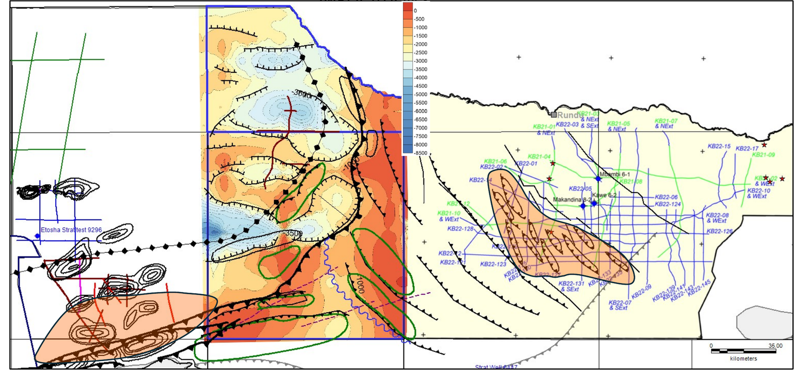
Structural interpretation visual supporting PEL 105 technical high-grading.
Structural Interpretation
Structural interpretation visual supporting PEL 105 technical high-grading.
Structural Interpretation
Structural interpretation visual supporting PEL 105 technical high-grading.
Initial Exploration Period Work Programme
| Workstream | Description | Purpose |
|---|---|---|
| Remote sensing | Analysis of satellite and remote-sensing datasets across the licence area. | Map surface geology, lineaments and access corridors at low cost and low impact. |
| Gravity & magnetics | Interpretation of existing airborne magnetic/radiometric and gravity data. | Define basin architecture, depth-to-basement and structural trends. |
| Geochemistry | Surface geochemical sampling and analysis programmes. | Screen for indications relevant to a potential petroleum system. |
| Passive seismic | Deployment and interpretation of passive seismic recordings. | Support basin-depth estimation and high-grading of areas of interest. |
| Integrated prospectivity analysis | Integration of all workstreams into a coherent basin and play model. | Identify and rank leads and fairways for the next exploration phase. |
| 2D seismic | Potential acquisition of 2D seismic lines over high-graded fairways. | Mature interpreted structures towards possible future drilling decisions. |
Remote sensing
- Description
- Analysis of satellite and remote-sensing datasets across the licence area.
- Purpose
- Map surface geology, lineaments and access corridors at low cost and low impact.
Gravity & magnetics
- Description
- Interpretation of existing airborne magnetic/radiometric and gravity data.
- Purpose
- Define basin architecture, depth-to-basement and structural trends.
Geochemistry
- Description
- Surface geochemical sampling and analysis programmes.
- Purpose
- Screen for indications relevant to a potential petroleum system.
Passive seismic
- Description
- Deployment and interpretation of passive seismic recordings.
- Purpose
- Support basin-depth estimation and high-grading of areas of interest.
Integrated prospectivity analysis
- Description
- Integration of all workstreams into a coherent basin and play model.
- Purpose
- Identify and rank leads and fairways for the next exploration phase.
2D seismic
- Description
- Potential acquisition of 2D seismic lines over high-graded fairways, subject to results and funding.
- Purpose
- Mature interpreted structures towards possible future drilling decisions.
Exploration Roadmap
Completed / ongoing
Phase 0: Foundations
Secure and maintain PEL 105; establish partnership framework; appoint technical adviser; begin ESG, community and stakeholder baseline work.
Current focus
Phase 1: Integrated Studies and High-Grading
Integrate remote sensing, gravity, magnetic, geochemical and passive seismic datasets; refine basin/play model; identify and rank leads and fairways.
Next phase
Phase 2: 2D Seismic Option and Capital Formation
Decide on 2D seismic over high-graded fairways; design and permit seismic lines; pursue capital raise or farm-in/joint-venture discussions.
Subject to funding and approvals
Phase 3: Drill-Ready Status and First Exploration Well(s)
Update prospect inventory; select priority drilling locations; secure partner and funding structure.
Success case only
Phase 4: Appraisal and Commercial Pathways
If a discovery occurs, implement appraisal, testing, additional seismic or wells as required.
Petroleum System Context
Integrated technical studies across PEL 105 are being used to refine basin understanding, identify areas of interest and support the staged progression from regional prospectivity assessment to seismic planning and, subject to results, future exploration drilling.
Potential Petroleum-System Implications
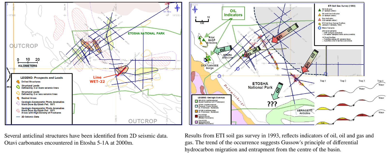
Potential petroleum-system implications interpreted from integrated regional and licence-scale datasets. Legend to accompany final asset.
Possible Migration and Trapping Scenarios
Possible migration and trapping scenarios considered as part of the evolving technical assessment. Legend to accompany final asset.
Explore the Next Phase of PEL 105
Exito welcomes engagement with aligned strategic, technical and financial partners interested in supporting the staged advancement of PEL 105.